Hinunangan (Hinunangan)
Hinunangan, officially the Municipality of Hinunangan (Kabalian: Lungsod san Hinunangan; Lungsod sa Hinunangan; Bayan ng Hinunangan), is a 3rd class municipality in the province of Southern Leyte, Philippines. According to the 2020 census, it has a population of 29,149 people.
Hinunangan is known as the "Rice Granary of the Province" for its vast plain land that is entirely planted with rice. Hinunangan has great potential for tourism because of its beautiful sandy beaches and islands. The town is also a producer of rattan and wood-based furniture, abaca handicraft items, pineapple, vegetables, other forest products, and bamboo furniture. It has a potential for mineral water and root crop processing and copper mining.
Hinunangan is also known as a major gateway in Leyte because of its near proximity to Tacloban City. The opening of Abuyog–Silago Road cuts travel time from Tacloban by half from the previous 6 hours to less than 3 hours. It is also the place in Southern Leyte with the most immigrants from Europe and North America.
It has a lot of tourist places, such as Tahusan, Talisay, or the twin islands (known as Cabugan Grande and Cabugan Chico as Pigafetta stated in his account during their travel with Magellan).. There are also hotels, inns, a public market, and beach resorts.
In 1521, Magellan recorded the sighting Hunonganan (Hinunangan) during the voyage in Leyte Gulf. As far back as 1750, Hinunangan was a mid-way station of Boholanos trading in Eastern Leyte. They rested overnight at the mouth of Das-ay River where they moored their boats. A shelter was built for the crews and tenders known as "hononganan" or stopover. Hence the name. In 1822, a certain Boholano named Palonoy founded Hinunangan. At this time, Silago to the north and Hinundayan and Anahawan to the south were part of Hinunangan.
In 1944, in the greatest naval battle in history the blocking warship of the Liberation waylaid the Japanese Fleet near Hinunangan. Thus, the area in Southern Leyte is the natural frontier of historically significant events in Philippine history.
Map - Hinunangan (Hinunangan)
Map
Country - Philippines
 |
 |
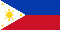
| Flag of the Philippines | |
Negritos, some of the archipelago's earliest inhabitants, were followed by successive waves of Austronesian peoples. Adoption of animism, Hinduism and Islam established island-kingdoms called Kedatuan, Rajahnates, and Sultanates. The arrival of Ferdinand Magellan, a Portuguese explorer leading a fleet for Spain, marked the beginning of Spanish colonization. In 1543, Spanish explorer Ruy López de Villalobos named the archipelago Las Islas Filipinas in honor of Philip II of Spain. Spanish settlement through Mexico, beginning in 1565, led to the Philippines becoming ruled by the Spanish Empire for more than 300 years. During this time, Catholicism became the dominant religion, and Manila became the western hub of trans-Pacific trade. In 1896, the Philippine Revolution began, which then became entwined with the 1898 Spanish–American War. Spain ceded the territory to the United States, while Filipino revolutionaries declared the First Philippine Republic. The ensuing Philippine–American War ended with the United States establishing control over the territory, which they maintained until the Japanese invasion of the islands during World War II. Following liberation, the Philippines became independent in 1946. Since then, the unitary sovereign state has often had a tumultuous experience with democracy, which included the overthrow of a decades-long dictatorship by a nonviolent revolution.
Currency / Language
| ISO | Currency | Symbol | Significant figures |
|---|---|---|---|
| PHP | Philippine peso | ₱ | 2 |
| ISO | Language |
|---|---|
| EN | English language |
| TL | Tagalog language |


